Commercial building documentation: exterior, structural cutaway, and interior plan views

Precision Commercial Building Documentation

High-Fidelity BIM and LiDAR Scanning

Get an Existing Conditions Documentation Quote

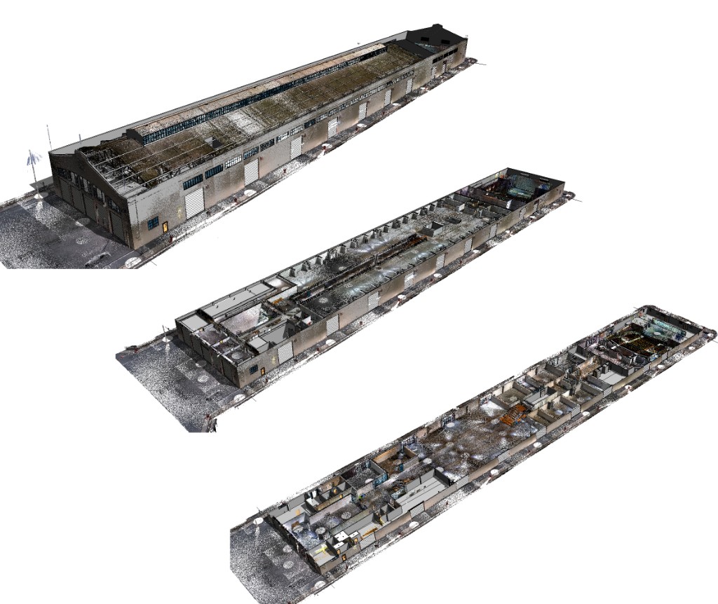
Ground Truth specializes in precision building documentation for commercial projects, delivering high-fidelity Building Information Models (BIM) to the industry’s most demanding clients, including NVidia, JLL, and Gensler. We utilize state-of-the-art technologies, including high-definition Light Detection and Ranging (LiDAR) scanning and comprehensive 360° photography, to create the essential, verifiable digital record required for modern commercial planning, construction, and facility management needs.

Read more

Commercial existing conditions documentation serves as the foundational input for subsequent schematic design, detailed engineering, and construction planning phases. The ultimate value of our documentation lies in establishing a single, verifiable, three-dimensional, digital record of the project site, mitigating risk and accelerating the path from existing conditions to successful project delivery for all stakeholders.

Our Comprehensive Documentation Deliverables

We combine quantitative precision with qualitative richness to ensure maximum utility across diverse project stakeholder needs.

The Detailed Revit Model (BIM)

The Revit model is the cornerstone of our commercial existing conditions documentation. This Building Information Model is meticulously generated from comprehensive LiDAR scanning data, augmented and verified by extensive 360° photographic documentation.

  • Foundation for Design: The model serves as the primary input for architects and engineers embarking on schematic design and advanced planning.
  • Level of Detail (LOD) Flexibility: Models can be tailored to specific project requirements, ranging from Schematic (LOD 200), which is suitable for early-stage planning, up to Detailed (LOD 300+).
  • System Inclusion: Detailed LOD 300+ options include accurate representation of building systems and fixtures such as Furnishings (fixed and FF&E), detailed HVAC and Piping runs (as visible), and accurate Material Assignment based on site verification.

The Complete Data Package

Our data package ensures all project needs—from raw data to sharable visuals—are met.

  • Point Clouds (Registered and Cleaned): The raw data backbone of the BIM model is delivered as a high-fidelity record. Point cloud files are universally compatible, ensuring they can be imported and utilized in virtually any current CAD or 3D Modeling program for independent verification or future modeling tasks.
  • 2D Construction Drawings: Professional drawing sets are generated directly from the accurate 3D model, ensuring dimensional consistency. We provide custom-branded PDF drawing sets for official submissions and editable DWG/DXF files for consultants. Deliverables include annotated and scaled Floor plans, Exterior Elevations, and Building Sections.
  • Visual Documentation: Comprehensive 360° photo documentation provides immersive virtual site access for all stakeholders, reducing the need for repeated site visits. We also provide traditional 2D photos capturing specific details and textures, alongside Site and Roof Drone Photography/Video for critical aerial perspectives.
  • 3D BIM Model: The 3D BIM Model, typically delivered as Revit 2026 model, is the cornerstone of our commercial existing conditions documentation. The models can be tailored to specific Level of Detail (LOD) requirements, from Schematic (LOD 200) up to Detailed (LOD 300+), ensuring maximum utility across diverse project stakeholder needs. Optionally, BIM models can be annotated with item specific data including manufacturer, model, source, maintenance documentation and more.

Advanced Visualization & Collaboration

Leveraging the fidelity of the Revit model, we facilitate rapid and effective communication of the existing building conditions.

  • Sharable 3D Walkthroughs: We offer quick conversions of the Revit model into lightweight, traversable 3D environments that can be easily shared with non-technical stakeholders via software-free web interfaces.
  • Visualization Mesh Outputs: Polygon mesh outputs (OBJ files) are available for seamless integration into specialized architectural visualization software, rendering engines, and game development platforms (e.g., Unreal Engine, Unity).

Our Dual-Speed Scanning Process

Ground Truth employs two scanning methods to optimize documentation for accuracy and speed:

  • High Accuracy Scanning: Stationary LiDAR scanners are used where exceptionally high precision is critical, yielding a point cloud accuracy of up to 2mm in most standard environments.
  • High Speed, Medium Accuracy Scanning: Mobile LiDAR SLAM scanners rapidly measure larger areas (100,000+ sft per day) with point cloud accuracy between 6mm to 2cm, ideal for projects with lower precision requirements.

Our documentation is invaluable for building owners, property managers, architects, engineers, space/event planners, and interior architects who require foundational intelligence for confident decision-making.

Download White Paper

Who we serve

Ready to document your commercial project with precision?

Get in Touch

Property types documented

Discuss scope, deliverables, and timeline with our team.

Get in Touch

Project types

Recent blog content

Start with a conversation about your documentation needs.

Get in Touch