Construction site with surveyor using a tripod-mounted LiDAR scanner and tablet under a clear sky

Existing Conditions Documentation for Construction Progress Monitoring

Leveraging LiDAR Scanning for Accurate Reporting

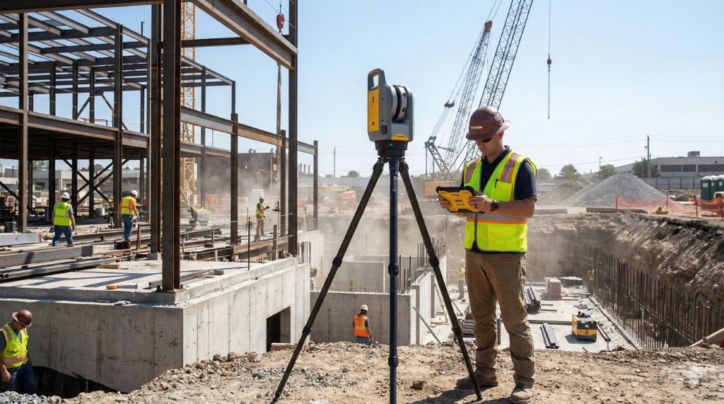
The construction industry operates under immense pressure from tight schedules and budgets, making efficient and accurate project documentation essential. Traditional documentation methods, relying on manual measurements, 2D drawings, and photographic records, are inefficient, subjective, and result in data that is often weeks old. These limitations lead to critical data gaps, prevent timely corrective action, and contribute to delays, rework, and costly disputes. Light Detection and Ranging (LiDAR) scanning is rapidly becoming a transformative, objective solution to these challenges.

How LiDAR Technology Works

LiDAR uses pulsed lasers to measure distances (Time-of-Flight), capturing millions of precise 3D measurements of a physical space with millimeter-level accuracy. This process generates a dense set of X, Y, and Z coordinates known as a point cloud, which serves as a highly detailed, time-stamped digital record of the as-built condition.

The progress documentation workflow involves:

Read more
  • Deployment: Portable or static scanners quickly capture large areas on-site.
  • Registration: Multiple scans are aligned into a single, cohesive point cloud representing the entire site.
  • Data Processing & Comparison: Specialized software overlays the registered point cloud (as-built) directly onto the original Building Information Modeling (BIM) design model (as-designed).
  • Progress Quantification: Operator supervised software compares the two models to quantify completed work (e.g., concrete volume, installed material) and highlights any deviations.
  • Deliverables: Output is a quantifiable progress report, often presented as heat maps showing deviations or color-coded progress maps tied to the project schedule.

Key Advantages for Construction

Integrating LiDAR into construction workflows delivers distinct advantages that enhance project quality and profitability:

  • Unparalleled Accuracy and Objectivity: Millimeter-level accuracy eliminates subjective guesswork, providing irrefutable evidence for quality assurance and minimizing costly rework.
  • Time Savings and Increased Frequency: The speed of data capture reduces time spent on manual documentation, allowing for daily or weekly scanning to provide a near-real-time view of progress.
  • Comprehensive Digital Twins (4D): Repeated scanning creates a series of 4D digital twins (3D spatial data over time). This archive is invaluable for future renovations (mapping concealed utilities), insurance/liability documentation, and final facility management modeling.
  • Direct BIM Integration: Enables automated model-based verification, including clash detection (installed elements versus planned location), tolerance checking, and automated progress validation for scheduling software.
  • Improved Collaboration and Safety: The 3D models allow remote stakeholders to virtually "walk through" the site. Furthermore, remote scanning reduces the need for personnel to take measurements in high-hazard areas.

Practical Applications

LiDAR is applied across various phases of a construction project:

  • Subcontractor Verification: Provides clear, objective metrics for confirming the volume and location of installed work to streamline and approve payment applications.
  • Earthwork Monitoring: Enables rapid and precise calculation of cut-and-fill volumes of excavation areas or material stockpiles.
  • Quality Control: Quickly generates detailed reports on the flatness of floors, the verticality of walls and columns, and the levelness of concrete slabs.
  • Dispute Documentation: The time-stamped point clouds create an unassailable record of construction events, protecting stakeholders if a dispute or delay arises.

Implementation Focus

To successfully integrate LiDAR, construction teams must plan for:

  • Hardware Selection: Selecting the correct scanner (handheld, terrestrial, or drone-mounted) based on the project size and required accuracy.
  • Data Processing Workflow: Investing in powerful computing hardware, specialized software, and training personnel to efficiently manage the registration and processing of point cloud data.
  • BIM Model Quality: Ensuring the original BIM model is clean and well-detailed, as automated analysis relies on the quality of the design input.
  • Trained Personnel: Deploying personnel trained in operating the scanner, civil engineering, surveying, and BIM principles to accurately interpret and integrate the data into project control systems.

LiDAR scanning moves construction progress monitoring beyond subjective analog methods, empowering project teams with objective, verifiable data for quality assurance and efficient management. As the technology becomes more integrated and accessible, its adoption will become indispensable for optimal efficiency and successful project delivery.

Download White Paper

Contact us for an Existing Conditions Documentation Quote.

Get in Touch

Additional services

Who we serve

Need progress scans, BIM comparison, or schedule-aligned reporting? Discuss scope with our team.

Get in Touch

Property types documented

A comprehensive list of types of buildings, sites, and campuses Ground Truth 3D has scanned, with links to content where available.

Discuss scope, deliverables, and timeline with our team.

Get in Touch

Recent blog content

Start with a conversation about your documentation needs.

Get in Touch