Property Owners
Property Documentation: Maximizing Value Across the Ownership Lifecycle
Detailed, accurate existing conditions documentation provides an indispensable foundation for landscape architects, providing the necessary tools to deliver great results and generate strong professional references. This documentation serves as a clear, easily communicated record of a site's current state, meticulously capturing topography, buildings, plantings, and all landscape features and elements. In an era of advanced design technology, high-quality documentation is critical because it forms the basis of a strong 2D or 3D model. These models, in turn, feed modern AI schematic design and visualization tools, which streamlines the conceptual process, powerfully communicates design intent, and stimulates client enthusiasm and buy-in.
A complete site photographic documentation package, delivered alongside laser scanned topography and planting measurement, makes repeated, time-consuming site visits unnecessary for basic fact-checking during design generation and collaboration. Employing this complete process improves planning, enhances communications, and helps avoid costly delays and rework, ultimately leading to better outcomes and significantly higher client satisfaction.
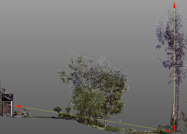
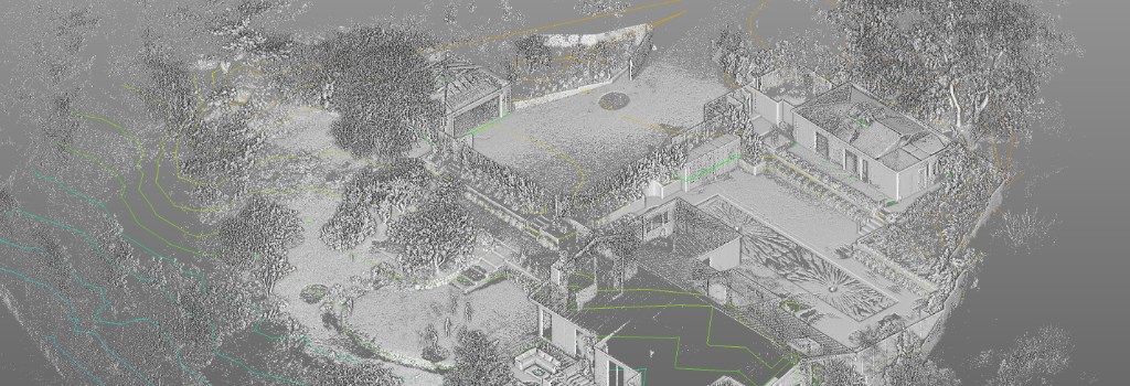
The deliverable package for Existing Conditions Documentation is robust, providing all necessary context in a precise, usable format. The core deliverable focuses on detailed 2D site plans, which are essential for accurate planning and include: accurate site topography; the locations of significant trees, defined as those greater than four inches in diameter; and the locations of buildings, hardscape, and all other site elements. These plans also contain spot elevations of steps, walls, and planting beds, as well as sill and head heights of windows for ensuring architectural integration, and the locations of neighboring buildings and fences for contextual awareness. When required, 3D models of the terrain and existing buildings may also be provided, which offer crucial visual context and function as a versatile, three-dimensional template for conceptualizing ideas.
The methodology for generating this detailed documentation is a streamlined, six-step process designed for efficiency and high accuracy. It begins with Project Planning (approx. one hour), followed by Data Collection (typically a single day) using state-of-the-art technologies such as LiDAR scanning, 360° photography, and drone photography. Next, the raw datasets undergo Data Assembly and Cleaning before being translated into precise digital representations during the Modeling step. This is followed by 2D Plan Preparation, where technical drawings are finalized and annotated, concluding with Quality Assurance (QA) to ensure all documentation meets required standards.
Accurate site data is more than a simple checklist; it is a fundamental tool that informs every creative and practical decision within a landscape project. Existing conditions documentation allows professionals to fully understand key site features and important details of existing structures, hardscape, and built elements, including heritage trees, retaining walls, fences, pools, water elements, trellises, and large stones. Beyond a physical inventory, the data is crucial for analyzing solar orientation, understanding prevailing wind patterns, and reviewing view corridors. A comprehensive LiDAR terrain map ensures that the precise locations of protected or Heritage trees are accurately identified and integrated into the design scheme. By starting with a high-fidelity representation of the existing site, landscape architects can mitigate risks, comply with local regulations, and unlock the full design potential of the property.
Investing in professional Existing Conditions Documentation is a preventative measure that yields significant returns by mitigating the risk of far greater expenses later in the project. Typical project costs range from $1,000 to $5,000, contingent upon the site's overall size, its landscape complexity, and the specific level of detail requested. The value derived is multifold: it improves planning by giving the landscape architect a comprehensive, factual understanding of all constraints and opportunities before the schematic design begins. Furthermore, it significantly enhances communications, providing a common, undeniable basis for discussions among all parties. Most importantly, this early investment avoids costly delays and extensive rework, which are often triggered by inaccurate measurements discovered deep into construction. By eliminating these common pitfalls, the documentation process minimizes change orders, ensures smoother project execution, and ultimately drives higher client satisfaction, shifting the design process from reactive problem-solving to proactive, informed creation.
Property Documentation: Maximizing Value Across the Ownership Lifecycle
Accurate plans and models fast
2D Plans, 3D models and thorough Photo Documentation
Planning for transition, growth and safety with ECD
Efficient, profitable, property operation and management with ECD
ECD: The Blueprint for Flawless Events
Cost Reduction and Risk Mitigation in Construction
An accurate foundation for success in modern landscape architecture
Planning a residential estate, campus, or public realm project? Discuss topography, planting survey, and deliverables with our team.
Get in TouchA comprehensive list of types of buildings, sites, and campuses Ground Truth 3D has scanned, with links to content where available.
Discuss scope, deliverables, and timeline with our team.
Get in TouchStart with a conversation about your documentation needs.
Get in Touch