Property Owners
Property Documentation: Maximizing Value Across the Ownership Lifecycle
Whether you are planning a kitchen remodel, a second story, or a whole-house renovation, single family homes demand accurate existing conditions documentation—often long after original drawings are lost or out of date. Ground Truth 3D captures your house with high-accuracy LiDAR scanning and comprehensive 360° photography, then delivers dimensionally accurate 2D plans, elevations, sections, and detailed 3D models. That foundation lets homeowners, architects, designers, and builders align on scope, budget, and permits without costly surprises or repeat field visits.
A typical capture takes a few hours on site for a representative home; deliverables are assembled by modeling specialists from the point cloud and imagery. The result is a shareable, perpetual digital record of your property—the same “ground truth” approach we apply across residential and commercial work, tuned to the scale and detail single family projects require.
The Ground Truth 3D deliverables and their applications
Ground Truth 3D offers comprehensive existing conditions measurement and modeling services globally. The final deliverables are meticulously generated by skilled modeling experts from raw data captured via LiDAR scanning and 360-degree photography. A typical project takes about one week from the on-site reality capture (4–6 hours for a 4,000 sq ft house) to project delivery following asset assembly and modeling phases.
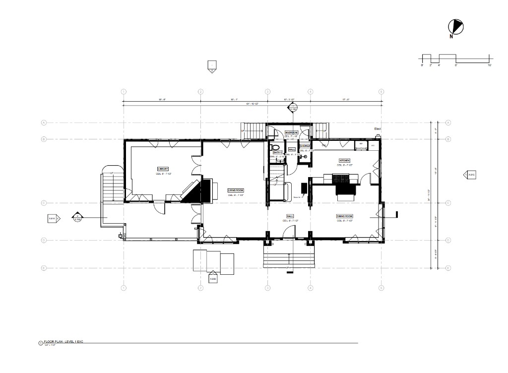
We provide dimensionally accurate 2D home plans, elevations, and sections, eliminating the need for manual measurements. For interior work, we supply schematic or detailed interior elevations, including critical dimensions like ceiling heights and the location of switches, outlets, and registers. These plans are the critical starting point for renovation planning and interior remodeling, allowing designers to efficiently generate options and estimate costs. Using captured data, we can also generate accurate electrical and lighting existing conditions plans, simplifying home electrical system updates.
We generate highly accurate 3D Revit models tailored to the client’s level of detail needs. These models include accurate building shells, structural elements, doors, windows, and major interior fixtures. BIM modeling allows for the addition of significant data annotations, such as wall assembly details and equipment information, saving time in renovation planning and ongoing operation. The detailed models are essential for development assessment, helping clients evaluate remodel potential, and are a powerful resource for permit planning, streamlining the submission process to regulatory bodies. They are also crucial for design visualization, enabling the seamless integration of proposed designs into the existing environment for high-fidelity renderings and immersive virtual reality formats.
Residential 3D models include immediate surrounding hardscape, decks, and topography. Additional modeling is available for major vegetation, retaining walls, fences, and other landscape features. LiDAR site scans capture landscape details with high precision, allowing for accurate placement and analysis of vegetation for health, views, and fire safety, and are often useful in permitting.
Comprehensive 360° photography assists in accurate model conversion and provides a virtual review capability for designers, eliminating repeat site visits. The output of a LiDAR scan is a three-dimensional point cloud—a collection of billions of colored dots that accurately represent the scanned site. Both the photographs (hundreds per typical project) and the point clouds are shared with the client and serve as an invaluable, permanent digital archive for historic documentation, preservation, and future planning.
Property Documentation: Maximizing Value Across the Ownership Lifecycle
Accurate plans and models fast
2D Plans, 3D models and thorough Photo Documentation
Planning for transition, growth and safety with ECD
Efficient, profitable, property operation and management with ECD
ECD: The Blueprint for Flawless Events
Cost Reduction and Risk Mitigation in Construction
An accurate foundation for success in modern landscape architecture
Planning a single family renovation or addition? Talk to us about capture scope and deliverables.
Get in TouchA comprehensive list of types of buildings, sites, and campuses Ground Truth 3D has scanned, with links to content where available.
Discuss scope, deliverables, and timeline with our team.
Get in TouchStart with a conversation about your documentation needs.
Get in Touch